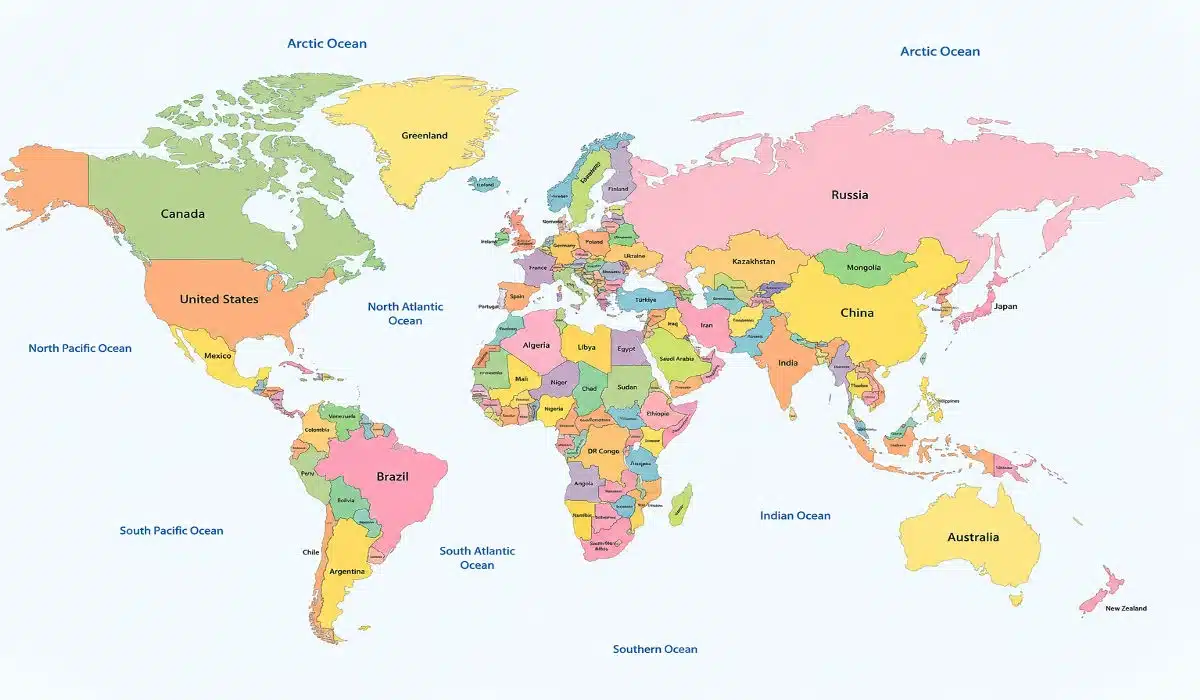
To truly grasp what is a political map, one must look beyond the colors and lines. At its core, a political map is a visual representation of human authority and jurisdictional limits. These maps do not show the height of a mountain or the depth of an ocean; instead, they show where one person’s laws end and another’s begin.
The Core Definition and Purpose
When asking what is a political map, the simplest answer is that it is a map showing territorial borders. These borders are often established by treaties, wars, or historical agreements.
Administrative Units: These maps display countries, states, provinces, cities, and towns.
Human-Centric: They focus on where people live and how they govern themselves.
Navigation of Power: They help diplomats, students, and travelers understand which government has jurisdiction over a specific piece of land.
Key Features of a Political Map
A defining factor in understanding what is a political map lies in its specific design elements. Cartographers use a set of standardized symbols to ensure these maps are easy to read.
Solid and Dashed Lines: International borders are usually thick solid lines, while internal state or provincial borders are thinner or dashed.
Color Differentiation: To answer what is a political map visually, notice how neighboring countries are painted in different colors. This isn’t for beauty; it’s to help the eye distinguish between different nations quickly.
City Symbols: Capital cities are often marked with a star inside a circle, while other major cities are marked with dots.
Water Bodies: While not the focus, major lakes and oceans are included to provide context for the land boundaries.
Political Map vs. Physical Map
To fully understand what is a political map, you must compare it to its counterpart: the physical map.
Physical Maps: Focus on natural features like elevation, deserts, and rainforests. They use greens and browns to show terrain.
Political Maps: Focus on the “invisible lines” created by humans. A physical map might show the Andes Mountains, but a political map will show that those mountains are split between Chile and Argentina.
Why Do Political Maps Change?
One fascinating aspect of what is a political map is that it is never permanent. Physical maps rarely change (unless over millions of years), but political maps can change overnight.
Independence Movements: New countries, like South Sudan in 2011, require the world to redraw the map.
Annexation and Conflicts: As we have seen in the mid-2020s, geopolitical shifts and conflicts can alter recognized borders.
City Growth: As urban areas expand, new administrative lines are drawn to manage growing populations.
The Role of Political Maps in 2026
In our modern era, the question of what is a political map has moved into the digital space.
GPS and Digital Cartography: Platforms like Google Maps allow users to toggle between a “Default” (political) view and a “Satellite” (physical/hybrid) view.
Geopolitics: In 2026, political maps are essential for discussing trade agreements, immigration policies, and international defense alliances.
Read More:How Many Jobs Are Available in Finance
Representation of Disputed Territories
One of the most complex aspects of what is a political map is how it handles disputed land. In regions like Kashmir, the South China Sea, or parts of Eastern Europe, borders are not universally agreed upon.
The Cartographic Solution: You will often see “dashed” or “dotted” lines in these areas, indicating a “Line of Control” rather than a recognized international border. This shows that the map is not just a drawing, but a political statement reflecting the publisher’s viewpoint or international law.
From Global to Local
To truly understand what is a political map, you must recognize that they exist at multiple scales.
World Political Maps: Focus on sovereign nations and oceans.
Regional Maps: Focus on continents like Europe or Asia, highlighting trade blocs (like the EU).
Local/City Maps: These are still political maps because they show ward boundaries, school districts, and voting precincts. Every time you look at a map of “City Zones,” you are looking at a specialized political map.
The Use of Map Projections
When asking what is a political map, we must consider “Projections.” Because the Earth is a sphere and a map is flat, some distortion always occurs.
Mercator vs. Peters: A Mercator political map makes northern countries like Greenland look massive, while a Gall-Peters projection shows countries in their correct size proportions. This is crucial for what is a political map because it influences how we perceive the “importance” and “size” of different nations.
Human Settlements and Urban Centers
A key feature in the anatomy of what is a political map is the hierarchy of human settlements.
Population Indicators: Political maps use different font sizes and symbols to denote the importance of a location. A bolded, underlined name usually represents a national capital, while smaller text indicates towns or villages. This helps users understand the administrative weight of different geographical points.
Maritime Boundaries and Exclusive Economic Zones
In 2026, the question of what is a political map has extended far into the ocean.
The Blue Map: Modern political maps often include “Maritime Borders.” These lines mark the 12-nautical-mile territorial sea and the 200-nautical-mile Exclusive Economic Zone. This is vital for understanding which country has the right to fish or drill for oil in specific parts of the ocean.
The Impact of Digital “Live” Political Maps
The traditional paper version is no longer the only way to define what is a political map. In the digital age, these maps are “dynamic.”
Real-time Updates: Digital political maps can update instantly during elections to show “Red vs. Blue” states or during conflicts to show shifting frontlines. This interactivity has turned the political map from a static reference into a live data visualization tool.
FAQ
Q1: What is a political map’s most important symbol?
Ans: The border line. Without clearly defined boundaries, a map cannot be classified as political.
Q2: Can a map be both political and physical?
Ans: Yes, these are called “Thematic” or “Hybrid” maps. They show mountain ranges and rivers but also overlay state and country borders.
Q3: Why are some borders straight lines?
Ans: Straight borders are usually “Geometric Borders.” They are often drawn along lines of latitude or longitude, common in parts of Africa and the Western United States.

Mr. Udoy is a professional Web Developer and Blogger with 7+ years of experience in the tech world. He specializes in web architecture and digital storytelling. As the driving force behind worldincidents.com, he focuses on delivering high-quality, well-researched content to a global audience.